- The Keith Creek Corridor Study in Rockford outlines plans to restore 20 miles of creek and surrounding watershed which is currently subject to frequent flooding, poor water quality, and low public access. According to Lauren Kleve, an Environmental Planner for Region 1 Planning Council and main contact for the project: “The Keith Creek Corridor study recognizes the importance of bank stabilization efforts, prioritizing the portion of the creek near Churchill Park within the Keith Creek Neighborhood as it is located within a FEMA-identified floodplain. Stabilization efforts identified in the corridor study primarily include creek bed naturalization through removing the existing concrete channel, re-meandering the channel, planting native vegetation, and installing creekside riprap, which is a layer of large stones that protects soil from erosion in areas of high or concentrated flows. Current efforts of the Keith Creek Corridor study include identifying and applying for applicable grants to implement the study’s action items. Additionally, project partners have been working to acquire vacant and underutilized properties within the Keith Creek Corridor to repurpose them, mitigate flooding, and create a safe walkable community.” These green methods of creek naturalization and permeable greenspace acquisition will also slow the flow of the creek, enhance water quality, and add natural habitats.
FIELD NOTES BLOG
Shoring up the Shoreline
Sydney Sherbitsky
December 18, 2024
Shoreline Stabilization
Shoreline stabilization involves implementing features at the water’s edge to limit sediment erosion to protect the land from wave action and currents. This process is a form of bioengineering, applying engineering principles to solve biological challenges. Stabilization measures can be "gray" (hard structures) or "green" (nature-based solutions), which affect the coastline's vulnerability and resilience. This significantly impacts economic, social, and ecological shoreline security. Economically, the shoreline may support infrastructure, tourism, and fisheries. Socially, shorelines provide space for recreation and community connection. Ecologically, the shoreline provides specialized habitat, water filtration, and exchange of materials. Given these factors, choosing the right stabilization method is crucial. This decision must consider wave strength, storm surge, flood capacity, space constraints, and ecological goals based on the type of shoreline being protected.
Gray Methods
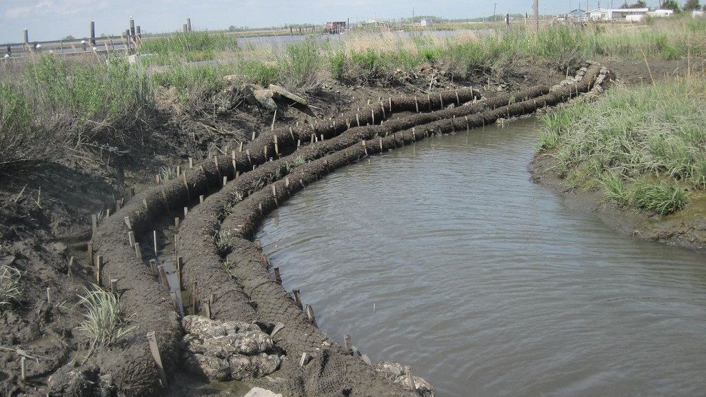
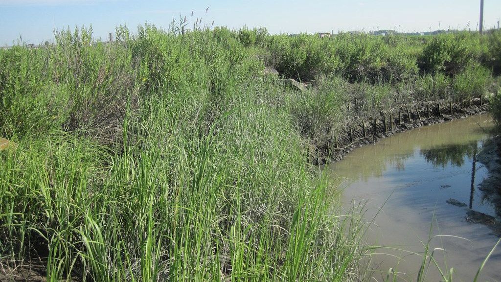
Gray methods involve hard, engineered structures that include breakwaters, groins, bulkheads, seawalls, and concrete channels. Hard structures reflect wave energy and are most effective in areas with high wave intensity or strong currents because they are best at quickly breaking up water energy. They are best used when the main goal is to keep sediments in place, space is limited, and there is valuable infrastructure close to the shoreline. However, gray methods have drawbacks. They offer little to no ecosystem benefits, provide no flood water storage capacity, reduce water circulation leading to degraded water quality, and may cause additional erosion in unprotected areas.


Green Methods
Green methods use natural solutions including vegetation, beach nourishment, or restored coastal habitat such as marshes, dunes, riparian zones, or oyster reefs. These methods are human engineered to mimic the physical, biologic, geologic, and chemical processes that already occur in nature. These techniques are most effective in areas with lower water energy the vegetation can withstand, as they absorb wave energy over a larger area. Due to its greater space and permeable components, natural stabilization features have a large flood water storage capacity and can slow down water flow. Natural features offer several ecological benefits including improved water quality and enhanced habitats for wildlife. They also provide long-term sustainability by maintaining the connection between water and land for sediment, water, and nutrient exchange. However, natural methods require more space, and are less effective in high energy environments. Additionally, most contract work and regulatory policy is centered around traditional hardened gray shorelines, not natural shorelines, which can make the process challenging.
Mixing Methods for Balanced Solutions
In many cases, a combination of gray and green methods may offer the best solution for shoreline stabilization. By blending hard structures with natural features, projects can balance wave energy reflection, flood water capacity, and ecological benefits. This hybrid approach can be tailored to the specific needs, resources, and security level of each shoreline. Some recent shoreline stabilization projects local to Northern Illinois have aimed to achieve that balance.
Local Projects
- The Illinois Beach State Park Shoreline Stabilization Project in Lake County was completed in September 2023. This project aimed to protect the last 2.2 miles of undeveloped natural shorelines along Lake Michigan in Illinois where it was previously eroding at a rate of 100 feet per year. The primary goal was to ensure the natural ecosystem of dunes, swales, marsh, and oak forest is preserved and protected for generations to come. The project involved the installation of offshore breakwater structures to decrease wave energy and slow sediment transport to reduce erosion. Habitat features, such as tern nests, limestone ledges, eco blocks, salvaged driftwood, and rock spurs, were also incorporated. This focus on habitat stabilization earned the project the Midwest’s first Waterfront Edge Design Guidelines Verification, which is a national rating system for resilient, ecological, and accessible waterfront projects. The combination of gray and green features ensures both environmental protection and public access to the beach.
- The Beverly Park Floodplain Reconnection is in the grant stage of The Illinois EPA Green Infrastructure Grant Opportunities Grant. The neighborhood of Beverly Park is economically disadvantaged and a flood prone community. This proposed project in Rockford’s Kent Creek watershed seeks to restore the floodplain by replacing the steep cracked concrete channel with a gentler, more permeable creek bed instead of repairing the channel. This naturalized area will increase flood water storage capacity, slow water flow, improve water quality, and restore riparian habitat with native vegetation. Beyond ecological benefits, this green methods project reduces flood risk as well as provides future green space and educational opportunities on stormwater pollution and naturalization benefits.
Takeaways
Severson Dells Nature Center is working on our own green method shoreline restoration at the former Elliot Golf Course. This project will bring the creek back to the surface in a process known as daylighting the creek. This project will improve water quality and reintroduce native plant species along the riverbanks to provide habitat and improve floodwater resilience. For more information on Elliot restoration check out our
Science of Rewilding blog post.
Shoreline stabilization is a critical tool for protecting coastlines for ecological health, community connection, and supporting local economies. Whether using gray hard structures or green natural methods, the goal is to enhance resilience and ensure long term sustainability. Local projects in Illinois demonstrate how blending both approaches can achieve a balanced, effective solution for shoreline protection.
Sources
HRGreen - Beavery Park Floodplain Reconnection
NOAA - Natural and Structural Measures for Shoreline Stabilization
Office of the Governor JB Pritzker Press Release - Gov. Pritzker Celebrates Ribbon Cutting at Illinois Beach State Park
Region 1 Planning Council, and The Lakota Group - Keith Creek Corridor Study
Severson Dells Field Notes Blog - The Science of Rewilding: Severson Dells Joins the Global Rewilding Alliance

RECENT ARTICLES

*please note: This blog was adapted from a blog series authored in 2023.

How to Safely dispose of common corrosive and hazardous household materials

When you think of summer in Illinois, you might picture swaying prairie grasses, tall oak trees, and, if you’re outside long enough, bugs. From the fireflies that light up July evenings to the pesky mosquitoes biting your ankles during a bonfire, insects are an inescapable part of our landscape. But they’re not just a buzzing background, bugs play essential roles in our ecosystems, gardens, and food systems. While some invasive insects threaten local biodiversity, most bugs are crucial contributors to a healthy environment. Insects are often overlooked– or worse, feared–but many are performing essential ecological services every day, and they deserve our thanks!